Flood Mapping Using Satellite Technology
by Nicole Mejia – Environmental Engineer at WKC Group
Introduction: Satellite Technology as a Critical Tool in Modern Flood Risk Management
Flooding remains among the most devastating natural disasters, posing substantial threats to communities, infrastructure and ecosystems. Severe events often lead to loss of life, damage to property, and degradation of habitats.
To minimise these effects, proper mitigation measures and flood risk reduction plans are essential. A key component of these strategies is accurate, timely flood data – and satellite technology plays a central role in delivering that.
Satellites capture high-resolution imagery and hydrological data, which can then be processed to produce a variety of flood maps. These maps enable rapid assessment of flood inundation extents, behaviour, characteristics and impacts, facilitating more effective decision-making for disaster management.

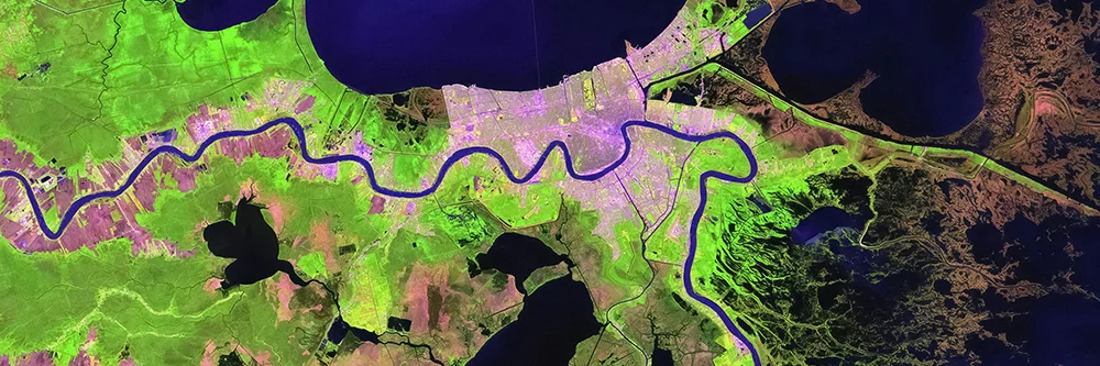
Satellite view of major flooding in the United Kingdom, February 2014
(Credit: NASA Earth Observatory)
Satellite Missions and Their Role in Flood Mapping
Satellites with their onboard optical and radar sensors are key to gathering flood-related data. These acquire data by capturing the spectral response of ground objects on different wavelengths allowing the identification and differentiation of various ground features, including water.
Optical Sensors
Optical sensors operate on the visible and near-infrared spectrum, enabling the detection of water features by contrasting them against vegetation, soil, or infrastructure.
Radar Sensors (SAR)
Radar sensors, such as Synthetic Aperture Radar (SAR), operate in the microwave region of the spectrum. They can penetrate cloud cover and collect data day or night, ensuring reliable flood monitoring even during storms.
Key Satellite Missions
Several satellite missions equipped with these sensors are commonly used in flood mapping due to their ability to provide accurate flood-related data.
- Sentinel-1 and Sentinel-2 (European Space Agency’s Copernicus Programme): combining SAR and multispectral sensors for high-resolution imagery.
- Landsat (USGS & NASA): the longest-running Earth observation mission, offering historical and contemporary datasets to analyse long-term flood patterns.
When integrated with Geographic Information Systems (GIS), these satellite-based sensors enable the creation of comprehensive flood maps, providing data on flood extent, depth, and behaviour.
Types of Geospatial Outputs Created with Satellite Data
Satellite-derived flood maps are essential tools for assessing and managing flood risks. Some of the most common types include:
Flood Extent Maps
These maps show the extent and area of a specific flood event inundating certain locations. These define the boundaries of the flood which is critical for planning emergency responses, evacuation routes and infrastructure protection.
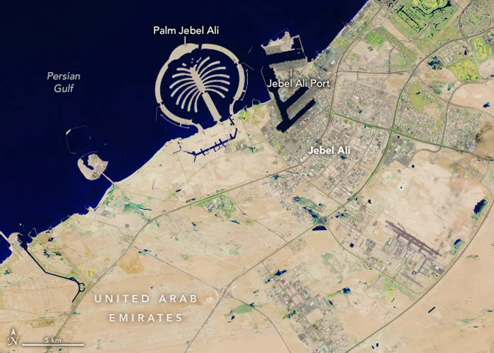
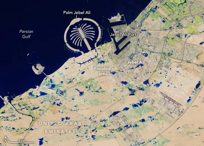
Satellite imagery showing flood extent in the United Arab Emirates, April 2024
(Credit: NASA Earth Observatory)
Historical Flood Maps

Manila 100-Year Flood Hazard Map produced under the Phil-LiDAR 1 Program
(Credit: Phil-LiDAR 1 Program / University of the Philippines Diliman)
These maps document the flood occurrences over a period allowing creation of time-series maps that reveal information regarding the dynamics, behaviour, and duration of this phenomena. This is crucial in assessing flood-risk areas vulnerable to recurring floods.
Flood Inundation Maps
These maps not just show the extent of flooding but also provide information regarding the depth and magnitude of flooding to further evaluate the severity of flooding. These allow deeper analysis of the intensity of floods including impacts to communities.

Flood-prone area map, Davao Oriental, Philippines (GIS-based hazard modelling)
(Credit: MDPI / Cabrera & Lee)
Flood Modelling Maps
Satellite data combined with hydrological data facilitate flood modelling simulations to examine depths, extents, and velocities of floods. These simulations are necessary for disaster preparedness.

Urban flood model & SAR-derived flood footprint merged with hazard maps (UK)
(Credit: MDPI / Water journal)
Conclusion: Enhancing Disaster Preparedness with Satellite Technology
The rapid, accurate generation of flood maps and models, combined with advanced GIS methods, enables a more effective response and assessment necessary for disaster planning and long-term mitigation strategies.
In the face of climate change, satellite technology will continuously play an increasingly important role in safeguarding communities from the devastating impacts of flooding.
At WKC Group, we provide satellite-based flood mapping services to support disaster response, strategic planning, and long-term risk reduction. By combining radar and optical satellite imagery with GIS tools, our team could help generate accurate flood extent and inundation maps that can be used for real-time assessments and future planning.
If you’re looking to strengthen your flood management strategies using satellite-driven data, feel free to reach out – our team would be happy to discuss how we can support your project.